وبلاگ دکتر علی کلانتری اسکوئی
وبلاگ علمی،آموزشی و خبری در رابطه با سامانه اطلاعات مکانی(GIS)وبلاگ دکتر علی کلانتری اسکوئی
وبلاگ علمی،آموزشی و خبری در رابطه با سامانه اطلاعات مکانی(GIS)
سامانه های نقشه برداری متحرک (Mobile Mapping Systems)
نقشه برداری موبایل فرآیند جمع آوری داده و اطلاعات مکانی از یک وسیله نقلیه متحرک می باشد که معمولا با مجموعه ای از تجهیزات عکاسی، Radar, Laser, LIDAR , و یا سایر سامانه های سنجش از راه دور انجام می شود. خروجی اولیه چنین سیستم هایی شامل داده های GIS، نقشه های رقومی و تصاویر و ویدئو های مکانمند می باشد (Wikipedia).
دانلود فایل مقدمه ای بر سامانه های نقشه برداری متحرک

معرفی یکی از شبیه سازهای آندروید در ویندوز
Nox App Player نرم افزاری مفید برای افرادی که طرفدار اندروید هستند و به شما این امکان را می دهد تا برنامه ها و بازی های اندروید خود را بصورت تمام صفحه در ویندوز اجرا کنید. توسط این برنامه میتوانید اپلیکیشن های اندروید را بدون داشتن گوشی یا تبلت اندروید، دقیقا به همان صورت در ویندوز خود تست و استفاده کنید. این بدان معنی است که می توانید از برنامه ای که روی دسکتاپ در حال نمایش است درست مثل زمانی که روی تلفن همراه خود با آن کار می کردید بهره مند شوید.
معرفی کتاب GNSS
Global Navigation Satellite Systems
and Their Applications
A ‘Short Book’ on Global Navigation Satellite Systems
2015 Springer
کتاب طراحی، توسعه و تسهیل شهرهای هوشمند (2017)
Designing, Developing, and Facilitating Smart Cities
Springer International Publishing Switzerland 2017
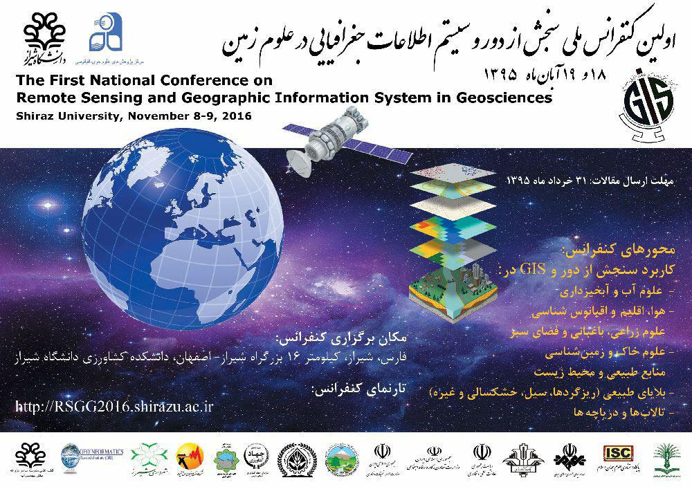
چهارمین کنفرانس کاربرد سامانه اطلاعات مکانی ( GIS ) در صنعت آب و برق - 1396

سازمان نقشه برداری کشور .
شرکت توزیع نیروی برق استان مرکزی.
استانداری استان مرکزی.
به میزبانی دانشگاه آزاد اسلامی واحد اراک .
مهلت ارسال چکیده مقالات:
مهلت ارسال متن کامل مقالات: اول آبان 1396
تاریخ برگزاری همایش: 22 و 23 آذر 1396
تلفن تماس دبیرخانه: 08632210361 - 08632231011
آدرس دبیرخانه: اراک ، میدان دارایی ، خیابان امام موسی صدر ، شرکت توزیع نیروی برق استان مرکزی، دبیر خانه کنفرانس
محل برگزاری: اراک - دانشگاه آزاد اسلامی واحد اراک
ایمیل: 4gis@mpedc.ir
وبلاگ ها و وب سایت های برتر در رابطه با سامانه های اطلاعات مکانی (GIS)
Top 60 GIS Blogs and Websites about Geographic Information Systems
معرفی Geo for All

پورتال های داده باز (Open Data Portals)
پورتال های داده باز ، پورتال های جدیدی هستندکه در بسیاری از کشورها انواع مختلف داده و اطلاعات را در دسترس عموم مردم قرار می دهند. داده های مکانی هم از طریق این پورتال ها قابل دسترس می باشند. کتاب زیر در قالب مجموعه ای از مقالات، اطلاعات بیشتری در مورد داده های باز ارائه نموده است.
An ebook on why opening up your data is
important and why you should care about it
در سایت زیر آدرس دسترسی به پورتال های داده کشورهای مختلف ارائه شده است.
A Comprehensive List of 2600 + Open Data Portals Around the World

ادامه دارد
مقاله ای در رابطه با دقت تعیین موقعیت با گوشی موبایل (iPhone)
Accuracy of iPhone Locations: A Comparison of Assisted GPS, WiFi and Cellular Positioning
Below are the results of this study including all three locational systems
3G iPhone w/ A-GPS ~ 8 meters
3G iPhone w/ wifi ~ 74 meters
3G iPhone w/ Cellular positioning ~ 600 meters
معرفی کتابی آنلاین با عنوان تجزیه و تحلیل مکانی - 2015
5th Edition-, 2015- de Smith, Goodchild, Longley
This Guide has been designed to be accessible to a wide range of readers — from undergraduates and postgraduates studying GIS and spatial analysis, to GIS practitioners and professional analysts. It is intended to be much more than a cookbook of formulas, algorithms and techniques ― its aim is to provide an explanation of the key techniques of spatial analysis using examples from widely available software packages.
نرم افزارهای تجزیه و تحلیل های مکانی Geospatial Analysis Softwares
سایتی که اطلاعات نرم افزارهای مورد استفاده در انواع تجزیه و تحلیل های مکانی را در اختیار شما قرار می دهد.
Geospatial Analysis Softwares
کتاب فناوری ماهواره
جهت دانلود به قسمت کتب تخصصی مراجعه شود.
SATELLITE TECHNOLOGY
PRINCIPLES AND APPLICATIONS
2014
کتاب Location-based Services به مجموعه کتب تخصصی وبلاگ اضافه شد
لطفا جهت دانلود کتاب به قسمت کتب تخصصی مراجعه نمائید.
کتاب Multicriteria Decision Analysis in Geographic Information Science به مجموعه کتب تخصصی وبلاگ اضافه شد
Multicriteria Decision Analysis in Geographic Information Science
By:
Jacek Malczewski
Claus Rinner
2015 Springer
کتاب Geographic Information Analysis به مجموعه کتب تخصصی وبلاگ اضافه شد
دانلود کتاب :
ویرایش ۲۰۱۰
Geographic Information Analysis
ویرایش ۲۰۰۲
Geographic Information Analysis