وبلاگ دکتر علی کلانتری اسکوئی
وبلاگ علمی،آموزشی و خبری در رابطه با سامانه اطلاعات مکانی(GIS)وبلاگ دکتر علی کلانتری اسکوئی
وبلاگ علمی،آموزشی و خبری در رابطه با سامانه اطلاعات مکانی(GIS)
در باره شاخص آمادگی زیرساخت داده های مکانی
شاخص آمادگی زیرساخت داده های مکانی مدلی جهت ارزیابی آمادگی یک کشور برای پذیرش و توسعه زیرساخت داده های مکانی می باشد. این مدل فازی پایه بر اساس فاکتورهای مختلف سازمانی، فناوری، اطلاعاتی و منابع انسانی و مالی تهیه شده است ( 16 شاخص) و نتایج حاصل از اجرای آن می تواند در شناسائی مشکلات و موانع اولیه ایجاد زیرساخت داده های مکانی مفید واقع گردد. اولین بار در 2005 توسط Delgado معرفی شده است.
ادامه دارد
27 تفاوت بین ArcGIS و QGIS
لینک زیر را ملاحظه فرمائید:
http://gisgeography.com/qgis-arcgis-differences/

گوگل ارث چینی
China to launch remote sensing system similar to Google Earth
Beijing, Aug 5 (EFE).- Chinese scientists announced they will launch China's first remote sensing satellite for commercial use in October on the lines of the popular Google Maps and Google Earth.The Jilin-1 satellite will put into orbit two satellites for videos, one for photographs and a fourth to test new space technology, Xuan Ming, board chairman of Chang Guang Satellite Technology Co Ltd told state-run Xinhua news agency.The project has been developed under the Changchun Institute of Optics, Fine Mechanics and Physics, Chinese Academy of Sciences.The satellites will focus on providing photographs to commercial clients, helping with harvest assessment, geological disaster prevention and resource surveys, Xuan explained.China's space program, with a large number of manned and lunar missions and a satellite program that has as clients countries from Asia, Africa and Latin America, has caught up with that of the U.S. and Russia.It is also developing its own version of the U.S. Global Positioning System, or GPS, using its BeiDou satellites.
CHINA SPACE | 05 de agosto de 2015
سمپوزیوم Towards a One-World Vision for the Blue Planet
The 9th International Symposium on Digital Earth
to be held in Halifax, NS, Canada, October 5-9, 2015
:Keynote speakers
فراخوان مقاله ISPRS/SMPR 2015 International Conference
جدید: مهلت ارسال چکیده مقالات به کنفرانس SMPR2015 تمدید شد!
جدید: آخرین مهلت ارسال چکیده مقاله: 1 مرداد1394
جدید: اعلام نتایج داوری چکیده مقالات: 15 شهریور 1394
جدید: آخرین مهلت ارسال مقاله کامل: 15 مهر1394
دایره المعارف سنجش از دور

دایره المعارف GIS را نیز از بخش کتب تخصصی همین وبلاگ می توانید دانلود نمائید.
سال نو با شعری زیبا
ضمن عرض تبریک سال نو و آرزوی موفقیت و سلامتی برای تمامی انسان ها ، شعر زیبا و پرمعنی زیر را تقدیم میکنم به همه آنهائی که همواره در تلاش و کوشش هستند.
About Landsat 8
Landsat 8 was launched February 11, 2013, and contains two sensors. One collects 8-band multispectral imagery at 30-meter resolution as well as panchromatic imagery at 15 meters. The other collects thermal imagery at 100-meter resolution. The orbit of the satellite results in its capturing 170-by-185-kilometer sized scenes along
a predefined path that returns to the same location every 16 days.
Ref:
,Esri News
for Map, Chart & Data Production Summer 2014
دستور IF اکسل و روش دومارتن
استفاده از IF های تودرتوی Excel، در بحث تصمیگیری ها، باعث افزایش دقت و سرعت می گردد، لذا این یاداشت را نوشتم همراه با یک مثال موردی یعنی کاربرد روش دومارتن درپهنه بندی اقلیمی .
در مجموع روش کار با IF های تودرتو در تمام مطالعات مشابه است فقط عناوین کلاس ها و یا معیارها تغییر می کنند.
******************************************************
کتابی در رابطه با پایان نامه نویسی

دانلود کتاب(به زبان انگلیسی- حدود 1.9 مگا)
*******************************************************
معرفی Whitebox Geospatial Analysis Tools
- Whitebox GAT now contains over 370 tools for performing advanced geospatial analysis, many of which are relevant for the field of geomorphometry.
- Whitebox is open-source and transparent software. The concept of software transparency that has guided the development of Whitebox is a very novel contribution and improvement over traditional open-source development strategies that we hope will encourage an active development community. Imagine using a GIS for a specific application or teaching. You may use a certain tool and wonder, 'how exactly does this work?' You might first try the help documentation, but it may not be detailed enough (i.e. down to the level of the implemented algorithm) to give you the information you desire. Now image that you could press a single button that is on the tool's dialog box and it would bring you to the very page in the enormous library of the GIS packages code that is the tool's algorithm. Even better, imagine that you then had the capability to translate the code from its original source file into a programming language that you can read! That's exactly what transparent software is all about.
جزئیات بیشتر در سایت WhiteBox
***************************************************
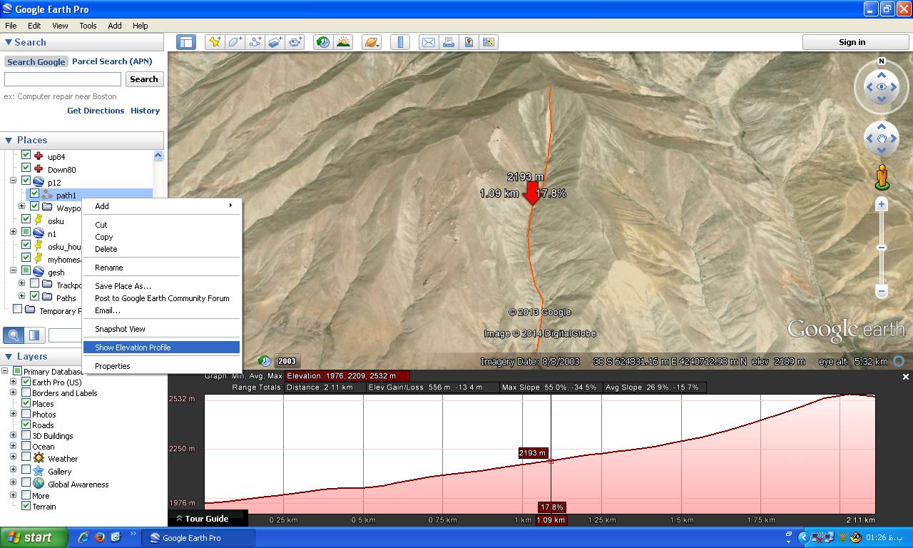
مشاهده پروفیل طولی و مشخصات شیب مسیر در Google Earth
ابتدا مسیر مورد نظر را ترسیم (Add
Path) و سپس در فهرست
Places روی نام لایه
Right Click نموده و گزینه Show
Elevation Profile را انتخاب کنید
 .
.
ارتباط SDI با GIS

SPOT 6
Launched in September 2012, SPOT 6 is the newest member of the SPOT family of satellites to be commercially available. SPOT 6 is an earth observation satellite offering a