وبلاگ دکتر علی کلانتری اسکوئی
وبلاگ علمی،آموزشی و خبری در رابطه با سامانه اطلاعات مکانی(GIS)وبلاگ دکتر علی کلانتری اسکوئی
وبلاگ علمی،آموزشی و خبری در رابطه با سامانه اطلاعات مکانی(GIS)
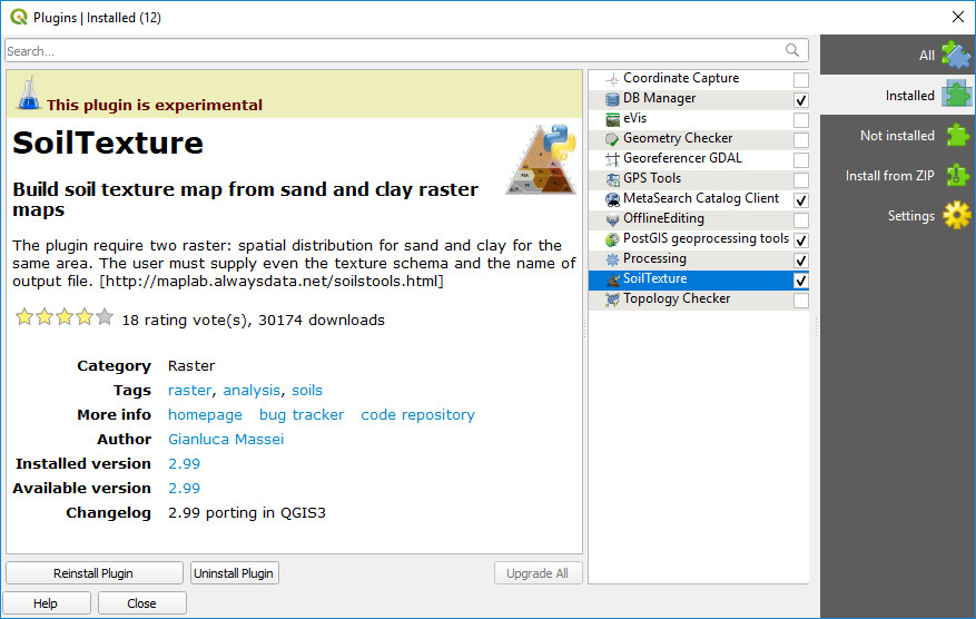
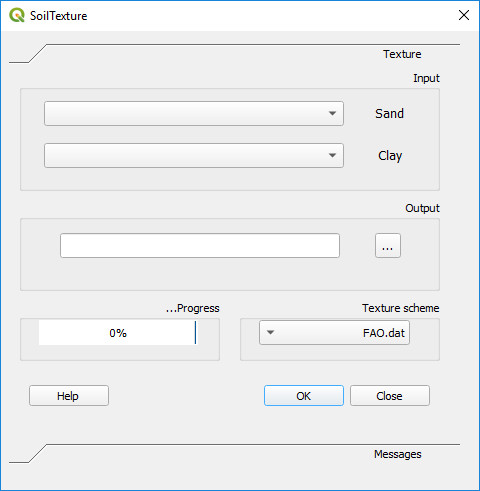
تهیه نقشه بافت خاک در QGIS
SoilTexture یکی از Plugin های ارزشمند (آزمایشی) میباشد که از نقشه های رستری رس و شن نقشه بافت تولید میکند. این Plugin را میتوانید پس از نصب QGIS از منو Plugins نصب کنید.
دو کتاب جدید به وبلاگ اضافه شد
1- Learning Geospatial Analysis with Python (2019)
Preface
The book starts by giving you the background of geospatial analysis, and then offers a flow of the techniques and technology used and splits the field into its component specialty areas, such as Geographic Information Systems (GIS), remote sensing, elevation data, advanced modeling, and real-time data. The focus of the book is to lay a strong foundation in using the powerful Python language and framework to approach geospatial analysis effectively. In doing so, we'll focus on using pure Python as well as certain Python tools and APIs, and using generic algorithms. The readers will be able to analyze various forms of geospatial data, learn about real-time data tracking, and see how to apply what they learn to interesting scenarios. While many third-party geospatial libraries are used throughout the examples, a special effort will be made by us to use pure Python, with no dependencies, whenever possible. This focus on pure Python 3 examples is what will set this book apart from nearly all other resources in this field. We will also go through some popular libraries that weren't in the previous version of the book.
Learning Geospatial Analysis with Python (2015)
2- QGIS Python Programming Cookbook (2015)
Preface
This book exploits the best features of QGIS to demonstrate over 140 reusable recipes, which you can use to automate workflows in QGIS or to build standalone GIS applications. Most recipes are very compact, and even if you can't find the exact solution that you are looking for, you should be able to get close. This book covers a lot of ground and pulls together fragmented ideas and documentation scattered throughout the Internet as well as the results of many hours of experimenting at the edges of the PyQGIS API.
در باره GeoAI
Geospatial Artificial Intelligence یا GeoAI ترکیبی از سیستم های اطلاعات مکانی(GIS) و ابزارهای هوش مصنوعی (AI) میباشد و امروزه یکی از موضوعات نسبتاً جدید عرصه GIS محسوب میشود.
در 260 سال گذشته ، ما سه انقلاب صنعتی را تجربه کرده ایم. اختراع موتور بخار راه را برای انقلاب اول هموار کرد. تولید انبوه برق در طول انقلاب دوم. الکترونیک و فناوری اطلاعات بر تولید خودکار حاکم بودند و بدین ترتیب انقلاب سوم به وجود آمد. اکنون با ظهور اینترنت اشیاء (IoT) و هوش مصنوعی از جمله GeoAI ، وارد انقلاب چهارم می شویم. این احتمال وجود دارد که ما ، متخصصان GIS ، برای درک و استفاده صحیح از GeoAI تلاش کنیم. سوال این است که چگونه می توانیم با استفاده از GeoAI با تغییر در زمان ، آماده شویم؟ این پست از اولین سری GeoAI است که به ما کمک می کند تا برای سازگاری شروع کنیم.
لطفا برای اطلاعات تکمیلی لینک های زیر را دنبال کنید:
کمک ESRI برای بحران کرونا
اخیرا آقای Jack Dangermond در اطلاعیه ای اعلام کرده که شرکت ESRI آماده است بدون دریافت هزینه در ساخت سایت GIS در ArcGIS Hub environment و سایر موارد کمک کند تا بهتر بتوان این بحران را مدیریت کرد.
همچنین هاب GIS کوید 19 نیز به آدرس زیر توسط این شرکت راه اندازی شده است:
متن اطلاعیه وآدرس آن در زیر آمده است.
https://go.esri.com/webmail/82202/733490520/8751347911c65ca4c6af7de37e57ff1b
|
|
|
|
|
|
|
|
|
|
|
|
|
|
|
|
|
|
|
|
|
آموزش استخراج زیرحوزه ها از DEM در محیط ArcGIS
Instruction for Watershed Delineation in
an ArcGIS Environment for Regionalization Studies
Department of Civil and Environmental Engineering
Western University, Canada
May 2014
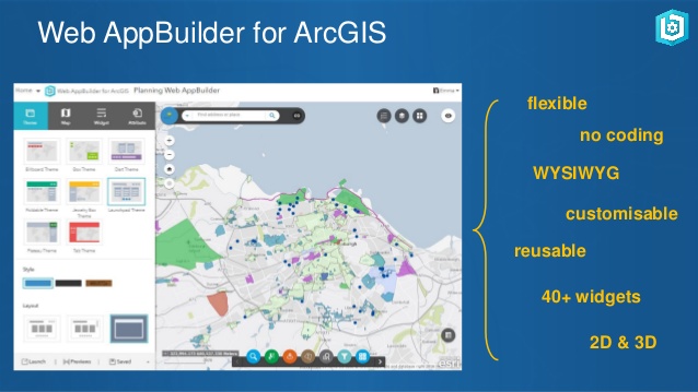
معرفی Web AppBuilder for ArcGIS
- Web AppBuilder for ArcGIS includes built-in tools so you can create 2D and 3D web apps for your workflows and your brand. It's user-friendly, flexible, and full of GIS functionality.
- Developers can build custom widgets and themes to extend Web AppBuilder for ArcGIS. Display and analyze your data on any device without writing code.
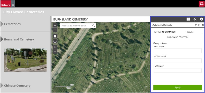
GIS گورستان های کلگری کانادا
- این برنامه با استفاده از Web AppBuilder for ArcGIS ساخته شده است و پایگاه داده آن هر روز به طور خودکار به روز می شود.
مصاحبه: The Power of PostgreSQL & PostGIS
The Power of PostgreSQL & PostGIS
Interview with Paul Ramsey
Abstract:
In this article, we speak to Paul Ramsey about how both PostgreSQL and PostGIS can provide a solid foundation for any small to large organisational GIS architecture. Paul, a Solutions Engineer at Carto, has been working with geospatial software for over 15 years: consulting to government and industry; building a geospatial software company; and programming on open source software. He co-founded the PostGIS spatial database project in 2001 and is currently an active developer and member of the project steering committee. In 2008, Paul received the Sol Katz Award for achievement in open source geospatial software, and he speaks and teaches regularly at conferences around the world. In the following discussion, Paul provides some insights into the market position of PostgreSQL and PostGIS compared to that of big-name vendor options.
Ref: GIS Professional Magazine
April 2018
ایده هائی برای بزرگداشت روز GIS در سال 2019
- Orginal Page: https://www.esri.com/about/newsroom/arcwatch/get-ready-get-set-and-then-go-to-gis-day-2019/
- Host an open house for your coworkers or people who live in your community. You may want your staff to give presentations about what role GIS plays within your organization and then present a few technology demonstrations. For example, the City of Rockwall, Texas, will host its sixth annual GIS Day on November 12. GIS and GPS technology will be on display. There will be a map gallery to view, along with educational videos. Yolo Countyin California will sponsor an open house on November 13 at the Yolo County Administration Building atrium in Woodland with lightning talks, a geo-Jeopardy game, and displays showcasing Yolo County projects that use GIS.
- Sponsor a map gallery, bring in speakers, and put on a map poster contest. That is what the University of California, Riverside (UCR), will do when the school hosts GIS Day at UCR 2019 from noon to 4:00 p.m., November 14, at the Orbach Science Library on campus. The event is open to the public.
- Design a GIS Day for children. That’s what the City of Boise, Idaho, plans as it hosts a Map Mania event for children aged 5 through 11 on November 15 at the Boise Watershed Environmental Education Center. The youngsters will learn to create maps, map a watershed, try their hand at geocaching, and participate in other activities. ISC in Regina, Saskatchewan, Canada, will hold a GIS Day workshop for children aged 5 through 11 at the Jack Mackenzie School on November 12. The kids will use GIS to analyze the features of their community and learn how to make a map using an aerial image. Another idea to try: Walk students through the process of making a story map using the new ArcGIS StoryMaps builder in ArcGIS Online. The new builder lets you add text, maps, photos, and videos with just a few clicks.
- Go big. Host a GIS conference with representatives from academia, government agencies, and information technology companies. That’s what Esri Bulgaria will do when the company sponsors GIS Day in Bulgaria at the Sofia Hotel Balkan on November 12. About 700 people are expected to attend.
- Go bigger. Host a technology carnival that incorporates GIS. That’s what the Innovation and Technology Commission in Hong Kong plans, beginning October 25 at the Hong Kong Science Park. The nine-day InnoCarnival 2019 will be a carnival-style gathering with a focus on technology, mainly for the youth. The estimated number of attendees: 200,000.
- Make your own GIS Day video, like this one called Make Every Day GIS Day, and then share it on your social media channels.
- Create your own georelated quiz using Survey123 for ArcGIS, ArcGIS StoryMaps, or the presentation capability in ArcGIS Online. Examples include Name That Place andWeird Earth. Or you can try to create a photo map quiz, such as that shown on slide 5 of the 5 Forces, 5, Trends, and 5 Skills in GIS story map or embed a quiz into a Story Maps Series app as the Port of Tacoma did for its GIS Day celebration in 2018.
- Get outside! Create a geocaching event at a park or your organization’s facility or property. Browse through this collection of geocaching courses that have been tested on a wide range of ages. You also can show your GIS Day attendees how to use one of Esri’s mobile data collection apps such as Collector for ArcGIS.
- Share with other people the fascinating characteristics of Earth using the ArcGIS Living Atlas of the World. These can include ecoregions on land or in the oceans, current weather, population, or natural hazards. Use web mapping applications, such as those focused on international migration, and precipitation, snowpack, and soil moisture, or compare senior population or current traffic in different urban areas around the world.. Understand how your community has changed via satellite imagery in the World Imagery Wayback app or by examining United States Geological Survey (USGS) historical maps.
- Invite other organizations that use GIS to your event. Watch this video from the Blinn Geographic Society at Blinn College in Texas, which invited many organizations to the campus to show students how GIS is used in real-world situations. Among the organizations that participated were the City of Bryan, Texas, and KBTX-TV, which uses GIS for weather tracking.
To register your upcoming GIS Day event and have it mapped and to download resources such as GIS Day posters, activities, and flyers, visit the GIS Day website. After GIS Day 2019 is history, please return to the site and share with the GIS world the story of what you did!
GIS Day provides inspiration to so many individuals who aspire to be part of the GIS Community. Capitalizing on the enthusiasm of elected officials, executives, co-workers, students, and friends is critical to furthering the momentum. Esri would like to support your local GIS community by providing five ArcGIS for Personal Use licenses to each GIS Day host who registers their event on the Esri website.
Each host can decide how to distribute these five licenses. This could be in the form of drawings, contests, young professionals network activities, as a gift to presenters, donations to nonprofits, or however you wish to further the GIS practice beyond GIS Day. Licenses must be redeemed by January 13, 2020.

7 چیزی که برای پربار کردن کارهایتان باید تعطیل کنید
اگر فرصت دارید این نوشتارانگلیسی را مطالعه کنید.
7 Things You Need To Stop Doing To Be More Productive, Backed By Science
Ref: https://medium.com/

کتاب Geospatial challenges in the twenty-first century
Key Challenges in Geography
EUROGEO Book Series
دانلود Python Add-In Wizard
تعریف پروژه موفق
کرزنر)2001) برای موفقیت پروژه تعریفی ارائه کرده که طی آن پروژه را زمانی موفقیت آمیز تلقی می کند که تحت شرایط زیر تکمیل شده باشد:
1) در بازه زمانی تخصیص یافته
2) در محدوده بودجه پیش بینی شده
3) در سطح عملکرد یا مشخصات مناسب
4) با رضایت کارفرما
5) محصول یا خدمات منتج از پروژه بطور واقعی قابل استفاده و بهر ه برداری باشد.
6) با کمترین تغییرات در محدوده پروژه یا با تغییرات پذیرفته شده دو طرفه
7) بدون برهم زدن جریان کاری اصلی سازمان
8) بدون تغییر دادن فرهنگ سازمان
Kerzner,Harold.(2001). International Institute for learning, strategic planning for project management using a project management maturity model.