وبلاگ دکتر علی کلانتری اسکوئی

وبلاگ دکتر علی کلانتری اسکوئی

وبلاگ علمی،آموزشی و خبری در رابطه با سامانه اطلاعات مکانی(GIS)
وبلاگ دکتر علی کلانتری اسکوئی

وبلاگ دکتر علی کلانتری اسکوئی

وبلاگ علمی،آموزشی و خبری در رابطه با سامانه اطلاعات مکانی(GIS)

گزارش اقتصاد مکانی کشور هلند

این گزارش  را حتماً بخوانید

NETHERLANDS GEOLOCATION ECONOMY REPORT

Market | Economy | Impact

The Netherlands Geolocation Economy report, prepared by Geospatial Media and Communications, in partnership with the Ministry of the Interior and Kingdom Relations of the Netherlands and Geonovum, highlights the value of the geospatial market of the Netherlands and the impact of the same on the country’s economy. The report emphasizes the need for transforming the current geospatial infrastructure model of a country to develop a Geospatial Knowledge Infrastructure (GKI) of tomorrow to integrate geospatial information, analytics, and visualization in order to aid effective decision-making across all sectors. Further, the report also showcases a comprehensive, collaborative, connected and innovative Digital Twin model encompassing engineering and geospatial tools to build a National Digital Twin.

REPORT HIGHLIGHTS:

Netherlands Geospatial Industry: Market Trends and Future Directions

Geospatial Industry Trends and Directions
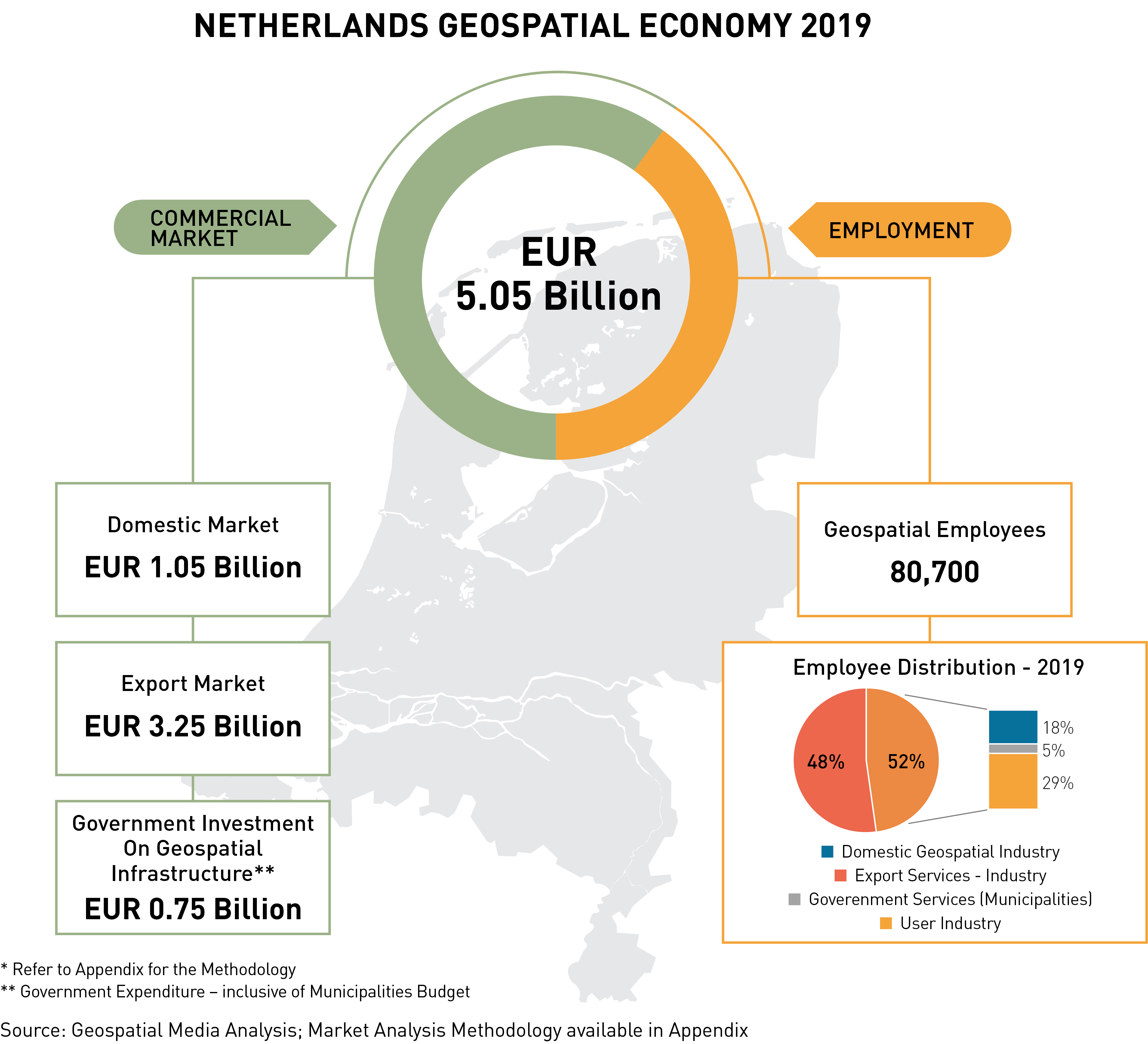
  • The Netherland's geospatial commercial industry market in 2019 is estimated to be EUR 1.05 billion. The geospatial services industry dominates the market with EUR 528 million market share, i.e., almost 50.2% of the total geospatial market of the Netherlands.
  • The infrastructure sector, which is often known to be a laggard in digitalization, has a significantly higher percentage share of the geospatial market, i.e., EUR 289 million – i.e., 27% of the total market share.
  • Up to EUR 239 million is estimated to be Netherland's geospatial import revenue from the subsidiaries, resellers, suppliers and distributors of the leading geospatial technology providers of the world such as Trimble, Esri, Hexagon, Nvidia, Oracle Spatial, Autodesk, Bentley Systems, among others.
  • Artificial Intelligence (AI), Machine Learning (ML), and the Internet of Things (IoT) are estimated to be the technology game-changer for the Netherlands geospatial industry.
  • The use of geospatial information and technology in the Netherlands is still highly driven by archetypal sectors like Defence and internal security, urban development, infrastructure, disaster management, and governance.

Geospatial – Human Resource Landscape

Geospatial – Human Resource Landscape
  • The Netherlands geospatial industry employs about 80,000 people across the country who specialize in geospatial and geospatial associated technologies.
  • Approximately 18% of the domestic geospatial industry employees are found to have Engineering as their core background specializing in survey engineering.
  • The majority of the geospatial professionals employed in the Netherlands geospatial industry have studied at the Technische Universiteit Delft (TU Delft). The university offers strategic courses in the geospatial sector focused on fundamental geospatial themes –GIS and cartography and 3D modelling, Digital Terrain Modeling (DTM), photogrammetry and 3D computer vision, geomatics, geoscience and remote sensing, and geo-data sets and database management.

The Netherlands Geospatial Economy 2019

In 2019, the Netherlands geospatial economy is valued at EUR 5.05 billion with the domestic market valued at EUR 1.05 billion; export market valued at EUR 3.25 billion and the government investment on Geospatial Infrastructure valued at EUR 0.75 billion.

Economic Impact of Geospatial Technologies and Solutions

Economic Impact of Geospatial Technologies and Solutions

  • The total business impact of the geospatial industry in the Netherlands is presently valued at EUR 31 billion.
  • The estimated consumer benefits basis a “willingness-to-pay” approach in the Netherlands amounts to a combined EUR 4.5 billion per year.
  • The Netherlands geospatial industry employs more than 80,000 people, and the potential employment indirectly linked to the geospatial industry value-chain is over 1.9 million jobs!
  • In comparison to 2019, the use of digital maps has reduced the CO2 emission from vehicular traffic by 18.5%.

Want to know more? Download the free report today and know the in and out of the Netherlands Geospatial Economy!