وبلاگ دکتر علی کلانتری اسکوئی

وبلاگ دکتر علی کلانتری اسکوئی

وبلاگ علمی،آموزشی و خبری در رابطه با سامانه اطلاعات مکانی(GIS)
وبلاگ دکتر علی کلانتری اسکوئی

وبلاگ دکتر علی کلانتری اسکوئی

وبلاگ علمی،آموزشی و خبری در رابطه با سامانه اطلاعات مکانی(GIS)

نرم افزار +GS

نسخه 5.1.1 همراه با کرک

Download GS+

Download Manual  in English (ver 10)


سایت های اینترنتی با دسترسی آزاد برای اساتید ، دانشجویان ، پژوهشگران و سایر علاقه مندان در دوران کرونا

سایت های اینترنتی در دوران کرونا با دسترسی آزاد به تمام اطلاعات

معرفی سایت هایی جهت دانلود رایگان کتاب :

سایتهای مهم علمی،پژوهشی

بانک های اطلاعاتی

پایان نامه های داخلی و خارجی

مقالات فارسی

کتابخانه ملی ایران، آمریکا و انگلیس

دسترسی آزاد روانشناسی و آموزش و پرورش:

اطلاعات عمومی کشورها:

مقالات رایگان کتابداری و اطلاع رسانی:

آرشیو مقالات از سال ۱۹۹۸

کتابخانه الکترونیک

رایانه و بانک های اطلاعاتی فارس:

دانشنامه آزاد اینترنتی:

دسترسی به متن کامل پایان نامه های 435 دانشگاه از24 کشور اروپایی:

دسترسی رایگان به بانک مقالاتدانشگاه کالیفرنیا:

دسترسی رایگان به بانک مقالات دانشگاه TENNESSEE:

دسترسی رایگان به 1,550,632 مقاله ی دانشگاهی:

دسترسی به پایان نامه های الکترونیکی دانشگاه ناتینگهام:

دسترسی رایگان به کتاب ها و ژورنالهای سایت In Tech:

دسترسی رایگان به مقالات علمی ،دانشگاه McGill  :

دسترسی رایگان به مقالات علمی،مقالات 1753 ژورنال- دانشگاهاستنفورد:

دسترسی به مقالات و متون علمی پایگاه Proceeding of the National Academy of Sciences ایالت متحده ی آمریکا:
http://www.pnas.org

توجه: همه آدرس ها را آزمایش نکردم شاید برخی کور باشند و یا محدود

برنامه asc2dssGrid

این برنامه تحت DOS اجرا شده و در مدلسازی به روش مدکلارک با نرم افزار HEC-HMS  استفاده می شود. لطفاً برای اطلاعات بیشتر به مقاله منتشر شده در نشریه مهندسی فناوری اطلاعات مکانی به آدرس http://jgit.kntu.ac.ir/article-1-60-fa.html مراجعه کنید.

Download  asc2dssGrid

Download gageInterpUserManual.pdf


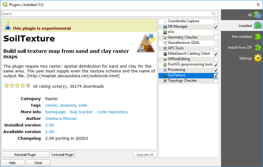
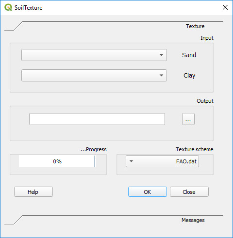
تهیه نقشه بافت خاک در QGIS

SoilTexture یکی از Plugin های ارزشمند (آزمایشی) می‌باشد که از نقشه های رستری رس و شن نقشه بافت تولید میکند. این Plugin را می‌توانید پس از نصب QGIS از منو Plugins نصب کنید.


دو کتاب جدید به وبلاگ اضافه شد

1- Learning Geospatial Analysis with Python (2019)

  Book's Codes 

Preface

The book starts by giving you the background of geospatial analysis, and then offers a flow of the techniques and technology used and splits the field into its component specialty areas, such as Geographic Information Systems (GIS), remote sensing, elevation data, advanced modeling, and real-time data. The focus of the book is to lay a strong foundation in using the powerful Python language and framework to approach geospatial analysis effectively. In doing so, we'll focus on using pure Python as well as certain Python tools and APIs, and using generic algorithms. The readers will be able to analyze various forms of geospatial data, learn about real-time data tracking, and see how to apply what they learn to interesting scenarios. While many third-party geospatial libraries are used throughout the examples, a special effort will be made by us to use pure Python, with no dependencies, whenever possible. This focus on pure Python 3 examples is what will set this book apart from nearly all other resources in this field. We will also go through some popular libraries that weren't in the previous version of the book.


 Learning Geospatial Analysis with Python (2015)


2- QGIS Python Programming Cookbook (2015)

Preface

This book exploits the best features of QGIS to demonstrate over 140 reusable recipes, which you can use to automate workflows in QGIS or to build standalone GIS applications. Most recipes are very compact, and even if you can't find the exact solution that you are looking for, you should be able to get close. This book covers a lot of ground and pulls together fragmented ideas and documentation scattered throughout the Internet as well as the results of many hours of experimenting at the edges of the PyQGIS API.

در باره GeoAI

Geospatial Artificial Intelligence یا GeoAI ترکیبی از سیستم های اطلاعات مکانی(GIS) و ابزارهای هوش مصنوعی (AI) می‌باشد و امروزه  یکی از موضوعات نسبتاً جدید  عرصه GIS محسوب می‌شود.

در 260 سال گذشته ، ما سه انقلاب صنعتی را تجربه کرده ایم. اختراع موتور بخار راه را برای انقلاب اول هموار کرد. تولید انبوه برق در طول انقلاب دوم. الکترونیک و فناوری اطلاعات بر تولید خودکار حاکم بودند و بدین ترتیب انقلاب سوم به وجود آمد. اکنون با ظهور  اینترنت اشیاء (IoT) و هوش مصنوعی از جمله GeoAI ، وارد انقلاب چهارم می شویم. این احتمال وجود دارد که ما ، متخصصان GIS ، برای درک و استفاده صحیح از GeoAI تلاش کنیم. سوال این است که چگونه می توانیم با استفاده از GeoAI با تغییر در زمان ، آماده شویم؟ این پست از اولین سری GeoAI است که به ما کمک می کند تا برای سازگاری شروع کنیم.

لطفا برای اطلاعات تکمیلی لینک های زیر را دنبال کنید:

https://resources.esri.ca/education-and-research/gateway-to-geoai-blog-series?mkt_tok=eyJpIjoiTVRZMFlUaGtPR0ZoWWpGaSIsInQiOiIyZFwvUk9QS21xR3dWNDhcL0RFV3IxbzRlT1J1ZXlcL3g0OVB3clZKNTdFb0RBM1c3Y3JcL3k4czZzNXRkQlBZaGpGckFGY3IxSVE4OTJjcVFDNklIa1lZWG9VaUFxVjZPdmhUZzlRdXZ5RFd5OHYrMFFFamNTcWFmWnJVWVB5NGRcL0xmIn0%3D


https://rdcu.be/b29bo

کمک ESRI برای بحران کرونا

اخیرا آقای Jack Dangermond در اطلاعیه ای اعلام کرده که شرکت ESRI آماده است بدون دریافت هزینه در ساخت سایت GIS در ArcGIS Hub environment و سایر موارد کمک کند تا بهتر بتوان این بحران را مدیریت کرد

همچنین هاب GIS کوید 19 نیز به آدرس زیر توسط این شرکت راه اندازی شده است:

https://coronavirus-resources.esri.com/?adumkts=industry_solutions&aduse=local_state&aduc=email&adum=list&utm_Source=email&aduca=mi_smart_communities&aduco=coronavirus_hub_resources&adut=950533&adupt=awareness&sf_id=7015x000000iQIAAA2&aducp=operational_second_body_text


متن اطلاعیه وآدرس آن در زیر  آمده است.


 https://go.esri.com/webmail/82202/733490520/8751347911c65ca4c6af7de37e57ff1b


Dear Esri User, 

 As the situation surrounding the coronavirus disease 2019 (COVID-19) continues to evolve, Esri is supporting our users and the community at large with software, services, and materials that are helping people understand, manage, and communicate the impact of the outbreak.
 
The following information may help you think through and respond more effectively using GIS and mapping for applications surrounding the pandemic.


Five Steps to Understanding the Potential COVID-19 Impact on Your Organization or Community

  1. Map the cases—Map confirmed and active cases, deaths, and recoveries to identify where COVID‑19 infections exist and have occurred.
  2. Map the spread—Time-enabled maps can reveal how infections spread over time and where you may want to target interventions.
  3. Map vulnerable populations—COVID‑19 disproportionally impacts certain demographics such as the elderly and those with underlying health conditions. Mapping social vulnerability, age, and other factors help you monitor at-risk groups and regions you serve.
  4. Map your capability to respond—Map facilities, employees or citizens, medical resources, equipment, goods, and services to understand and respond to current and potential impacts of COVID‑19.
  5. Communicate with maps—Use interactive Web maps, dashboard apps, and StoryMaps to help rapidly communicate your situation. 

If you need assistance, Esri has set up a focused support program that can help you and your organization manage this crisis. We are making resources available at no costthat can help you prepare, manage, and deliver an effective response to COVID‑19.


Access the Esri COVID-19 GIS Hub

On the COVID-19 GIS Hub, you will find valuable and ready-to-use demographic and other data from authoritative sources, our user community, and business partners. You will also find practical apps that immediately aid better understanding and decision-making. This includes a collection of datasets, applications, and other useful content for your planning and response. These materials will be updated with new content as it becomes available.


Build Your Own Hub Site with a Free ArcGIS Hub Template

To jump-start your own response, we are providing you an ArcGIS Hub Coronavirus Response template at no cost. The template includes examples, materials, and configurations to rapidly deploy your ArcGIS Hub environment. ArcGIS Hub is a framework to build your own website to visualize and analyze the crisis in the context of your organization's or community's population and assets.
 
If you do not have ArcGIS Online, Esri will donate ArcGIS Online with ArcGIS Hub Basic for six months. To activate your COVID-19 ArcGIS Online and Hub Donation, go tohttps://go.esri.com/e/82202/disaster/mz9mmw/733490520?h=DGrn3FY_1CUbP9EpBE_mfPqFtZGiAfy33TGfCH0t9Bs and click Request Assistance.
 
Once you have your donation or if you already have ArcGIS Online, go to the app launcher, navigate to ArcGIS Hub, click new site, browse the gallery, and activate the Coronavirus Response template.


Request Additional Assistance from Esri's Disaster Response Program

If your organization's GIS capacity is exceeded, and you need emergency support, there are several ways we may be able to help. We provide free GIS technology and on-call technical experts. We can help you with data, software, configuration, and technical support for your applications. For more than 25 years, Esri has supported our community with active emergency response and relief efforts. Our team is ready to help. 
 
If you need any assistance, please reach out to us athttps://go.esri.com/e/82202/disaster/mz9mmw/733490520?h=DGrn3FY_1CUbP9EpBE_mfPqFtZGiAfy33TGfCH0t9Bs and click Request Assistance. And, if you have data or solutions that would be useful to others, we encourage you to share them with us—we can include them in our COVID-19 GIS Hub and make them accessible to our global community. 

Esri will continue to do its best to support you by sharing resources and information on what other users are doing in response to COVID‑19.
Please stay safe and healthy during this time.


Sincerely,
 
Jack Dangermond
President
 
Este Geraghty, MD, MS, MPH, CPH, GISP
Chief Medical Officer


آموزش استخراج زیرحوزه ها از DEM در محیط ArcGIS


Instruction for Watershed Delineation in 

an ArcGIS Environment for Regionalization Studies

Department of Civil and Environmental Engineering

Western University, Canada

 May 2014

دانلود فایل


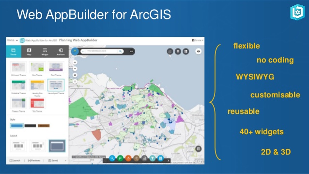
معرفی Web AppBuilder for ArcGIS

  • Web AppBuilder for ArcGIS includes built-in tools so you can create 2D and 3D web apps for your workflows and your brand. It's user-friendly, flexible, and full of GIS functionality.
  • Developers can build custom widgets and themes to extend Web AppBuilder for ArcGIS. Display and analyze your data on any device without writing code.

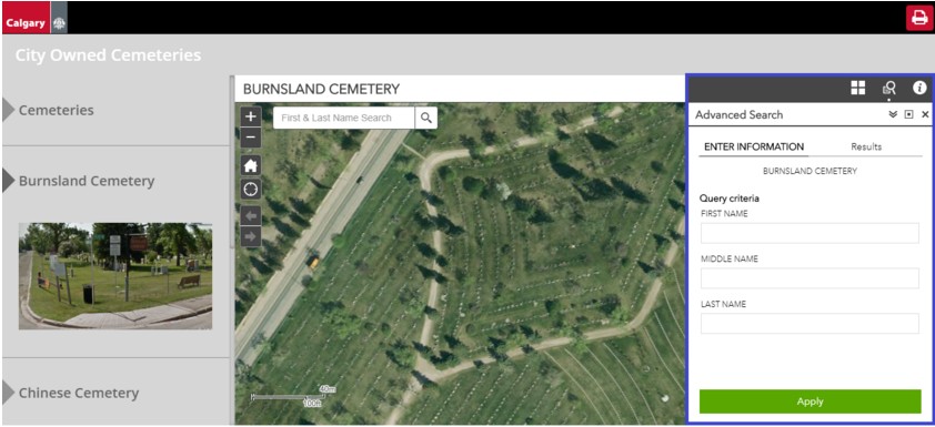
GIS گورستان های کلگری کانادا

گورستانها مکانهای خاصی هستند که خاطرات کسانی که پیش از ما رفته اند را حفظ و ارج می نهند. در کلگری برخی از گورستان ها به صورت خصوصی اداره می شوند ، برخی دیگر توسط شهرداری ها اداره می شوند. کلگری  دارای پنج قبرستان و یک مقبره سرپوشیده است. آنها با استفاده یک بانک اطلاعات مکانی قبرستان ها را با بیش از 138،000 سوابق فردی (نام ها ، مکان های نقشه و تاریخ دفن) مدیریت می کنند. برای  دسترسی عموم به این اطلاعات ، کلگری برنامه Cemeteries شهر را توسعه داده است. 
  • این برنامه با استفاده از Web AppBuilder for ArcGIS ساخته شده است و پایگاه داده آن هر روز به طور خودکار به روز می شود. 
منبع: Esri Canada-2019-1-Nov

مصاحبه: The Power of PostgreSQL & PostGIS

The Power of PostgreSQL & PostGIS

Interview with Paul Ramsey 


دانلود 

Abstract:

In this article, we speak to Paul Ramsey about how both PostgreSQL and PostGIS can provide a solid foundation for any small to large organisational GIS architecture. Paul, a Solutions Engineer at Carto, has been working with geospatial software for over 15 years: consulting to government and industry; building a geospatial software company; and programming on open source software. He co-founded the PostGIS spatial database project in 2001 and is currently an active developer and member of the project steering committee. In 2008, Paul received the Sol Katz Award for achievement in open source geospatial software, and he speaks and teaches regularly at conferences around the world. In the following discussion, Paul provides some insights into the market position of PostgreSQL and PostGIS compared to that of big-name vendor options.

Ref: GIS Professional Magazine

April 2018