وبلاگ دکتر علی کلانتری اسکوئی

وبلاگ دکتر علی کلانتری اسکوئی

وبلاگ علمی،آموزشی و خبری در رابطه با سامانه اطلاعات مکانی(GIS)
وبلاگ دکتر علی کلانتری اسکوئی

وبلاگ دکتر علی کلانتری اسکوئی

وبلاگ علمی،آموزشی و خبری در رابطه با سامانه اطلاعات مکانی(GIS)

معرفی اپلیکیشن Maps.me

جایگزینی برای گوگل مپ زمانی که در گوشی خود اینترنت ندارید
رایگان است Maps.me
Maps.me is a mobile app for Android, iOS and BlackBerry that provides offline maps using OpenStreetMap data. It was formerly known as MapsWithMe. In November 2014, it was acquired by Mail.Ru Group and became part of its My.com brand. Wikipedia
Fast, detailed and entirely offline maps with turn-by-turn navigation – trusted by over 140 million travelers worldwide
OFFLINE MAPS
Save mobile data, no internet is required
NAVIGATION
Use driving, walking and cycle navigation anywhere in the world
TRAVEL GUIDES
Save you time planning the trip and never miss an interesting place with our ready-made travel guides. We've partnered with the best travel content creators to build travel guide catalog for hundreds of destinations around the world. Whether you prefer city travel, car trips or outdoor activities you will find a great choice of guides for a perfect journey
INCREDIBLY DETAILED
Directions to points of interest (POI), hiking trails and places missing from other maps
UP-TO-DATE
Maps are updated by millions of OpenStreetMap contributors daily. OSM is an open-source alternative to popular map services
FAST AND RELIABLE
Offline search, GPS navigation along with optimized maps to effectively save memory space
BOOKMARKS
Save locations you love and share them with your friends
AVAILABLE WORLDWIDE
Essential for home and travel. Paris, France? Check. Amsterdam, Netherlands? Check. Barcelona, Spain? Check. New York, Chicago, Florida, Las Vegas, Nevada, Seattle, San Francisco, California, USA? Check! Rome, Italy? Check. London, UK? Check.
TRAFFIC DATA
New online city traffic maps. Check out updates on traffic info and fastest driving routes in 36 countries‌
AND MORE
– Search through different categories e.g. restaurants, cafes, tourist attractions, hotels, ATMs and public transport (metro, bus…)
– Make hotel bookings via Booking.com directly from the app
– Share your location via text message or social media
– When cycling or walking, the app shows whether the way is uphill or downhill
Continued use of GPS running in the background can dramatically decrease battery life

Ref: https://play.google.com/store/apps/details?id=com.mapswithme.maps.pro&hl=en&gl=US

سه کتاب به وبلاگ اضافه شد


قابل دانلود از بخش  کتب تخصصی

نرم افزار +GS

نسخه 5.1.1 همراه با کرک

Download GS+

Download Manual  in English (ver 10)


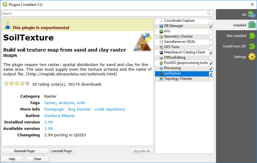
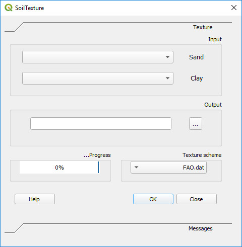
تهیه نقشه بافت خاک در QGIS

SoilTexture یکی از Plugin های ارزشمند (آزمایشی) می‌باشد که از نقشه های رستری رس و شن نقشه بافت تولید میکند. این Plugin را می‌توانید پس از نصب QGIS از منو Plugins نصب کنید.


در باره GeoAI

Geospatial Artificial Intelligence یا GeoAI ترکیبی از سیستم های اطلاعات مکانی(GIS) و ابزارهای هوش مصنوعی (AI) می‌باشد و امروزه  یکی از موضوعات نسبتاً جدید  عرصه GIS محسوب می‌شود.

در 260 سال گذشته ، ما سه انقلاب صنعتی را تجربه کرده ایم. اختراع موتور بخار راه را برای انقلاب اول هموار کرد. تولید انبوه برق در طول انقلاب دوم. الکترونیک و فناوری اطلاعات بر تولید خودکار حاکم بودند و بدین ترتیب انقلاب سوم به وجود آمد. اکنون با ظهور  اینترنت اشیاء (IoT) و هوش مصنوعی از جمله GeoAI ، وارد انقلاب چهارم می شویم. این احتمال وجود دارد که ما ، متخصصان GIS ، برای درک و استفاده صحیح از GeoAI تلاش کنیم. سوال این است که چگونه می توانیم با استفاده از GeoAI با تغییر در زمان ، آماده شویم؟ این پست از اولین سری GeoAI است که به ما کمک می کند تا برای سازگاری شروع کنیم.

لطفا برای اطلاعات تکمیلی لینک های زیر را دنبال کنید:

https://resources.esri.ca/education-and-research/gateway-to-geoai-blog-series?mkt_tok=eyJpIjoiTVRZMFlUaGtPR0ZoWWpGaSIsInQiOiIyZFwvUk9QS21xR3dWNDhcL0RFV3IxbzRlT1J1ZXlcL3g0OVB3clZKNTdFb0RBM1c3Y3JcL3k4czZzNXRkQlBZaGpGckFGY3IxSVE4OTJjcVFDNklIa1lZWG9VaUFxVjZPdmhUZzlRdXZ5RFd5OHYrMFFFamNTcWFmWnJVWVB5NGRcL0xmIn0%3D


https://rdcu.be/b29bo

کمک ESRI برای بحران کرونا

اخیرا آقای Jack Dangermond در اطلاعیه ای اعلام کرده که شرکت ESRI آماده است بدون دریافت هزینه در ساخت سایت GIS در ArcGIS Hub environment و سایر موارد کمک کند تا بهتر بتوان این بحران را مدیریت کرد

همچنین هاب GIS کوید 19 نیز به آدرس زیر توسط این شرکت راه اندازی شده است:

https://coronavirus-resources.esri.com/?adumkts=industry_solutions&aduse=local_state&aduc=email&adum=list&utm_Source=email&aduca=mi_smart_communities&aduco=coronavirus_hub_resources&adut=950533&adupt=awareness&sf_id=7015x000000iQIAAA2&aducp=operational_second_body_text


متن اطلاعیه وآدرس آن در زیر  آمده است.


 https://go.esri.com/webmail/82202/733490520/8751347911c65ca4c6af7de37e57ff1b


Dear Esri User, 

 As the situation surrounding the coronavirus disease 2019 (COVID-19) continues to evolve, Esri is supporting our users and the community at large with software, services, and materials that are helping people understand, manage, and communicate the impact of the outbreak.
 
The following information may help you think through and respond more effectively using GIS and mapping for applications surrounding the pandemic.


Five Steps to Understanding the Potential COVID-19 Impact on Your Organization or Community

  1. Map the cases—Map confirmed and active cases, deaths, and recoveries to identify where COVID‑19 infections exist and have occurred.
  2. Map the spread—Time-enabled maps can reveal how infections spread over time and where you may want to target interventions.
  3. Map vulnerable populations—COVID‑19 disproportionally impacts certain demographics such as the elderly and those with underlying health conditions. Mapping social vulnerability, age, and other factors help you monitor at-risk groups and regions you serve.
  4. Map your capability to respond—Map facilities, employees or citizens, medical resources, equipment, goods, and services to understand and respond to current and potential impacts of COVID‑19.
  5. Communicate with maps—Use interactive Web maps, dashboard apps, and StoryMaps to help rapidly communicate your situation. 

If you need assistance, Esri has set up a focused support program that can help you and your organization manage this crisis. We are making resources available at no costthat can help you prepare, manage, and deliver an effective response to COVID‑19.


Access the Esri COVID-19 GIS Hub

On the COVID-19 GIS Hub, you will find valuable and ready-to-use demographic and other data from authoritative sources, our user community, and business partners. You will also find practical apps that immediately aid better understanding and decision-making. This includes a collection of datasets, applications, and other useful content for your planning and response. These materials will be updated with new content as it becomes available.


Build Your Own Hub Site with a Free ArcGIS Hub Template

To jump-start your own response, we are providing you an ArcGIS Hub Coronavirus Response template at no cost. The template includes examples, materials, and configurations to rapidly deploy your ArcGIS Hub environment. ArcGIS Hub is a framework to build your own website to visualize and analyze the crisis in the context of your organization's or community's population and assets.
 
If you do not have ArcGIS Online, Esri will donate ArcGIS Online with ArcGIS Hub Basic for six months. To activate your COVID-19 ArcGIS Online and Hub Donation, go tohttps://go.esri.com/e/82202/disaster/mz9mmw/733490520?h=DGrn3FY_1CUbP9EpBE_mfPqFtZGiAfy33TGfCH0t9Bs and click Request Assistance.
 
Once you have your donation or if you already have ArcGIS Online, go to the app launcher, navigate to ArcGIS Hub, click new site, browse the gallery, and activate the Coronavirus Response template.


Request Additional Assistance from Esri's Disaster Response Program

If your organization's GIS capacity is exceeded, and you need emergency support, there are several ways we may be able to help. We provide free GIS technology and on-call technical experts. We can help you with data, software, configuration, and technical support for your applications. For more than 25 years, Esri has supported our community with active emergency response and relief efforts. Our team is ready to help. 
 
If you need any assistance, please reach out to us athttps://go.esri.com/e/82202/disaster/mz9mmw/733490520?h=DGrn3FY_1CUbP9EpBE_mfPqFtZGiAfy33TGfCH0t9Bs and click Request Assistance. And, if you have data or solutions that would be useful to others, we encourage you to share them with us—we can include them in our COVID-19 GIS Hub and make them accessible to our global community. 

Esri will continue to do its best to support you by sharing resources and information on what other users are doing in response to COVID‑19.
Please stay safe and healthy during this time.


Sincerely,
 
Jack Dangermond
President
 
Este Geraghty, MD, MS, MPH, CPH, GISP
Chief Medical Officer


آموزش استخراج زیرحوزه ها از DEM در محیط ArcGIS


Instruction for Watershed Delineation in 

an ArcGIS Environment for Regionalization Studies

Department of Civil and Environmental Engineering

Western University, Canada

 May 2014

دانلود فایل


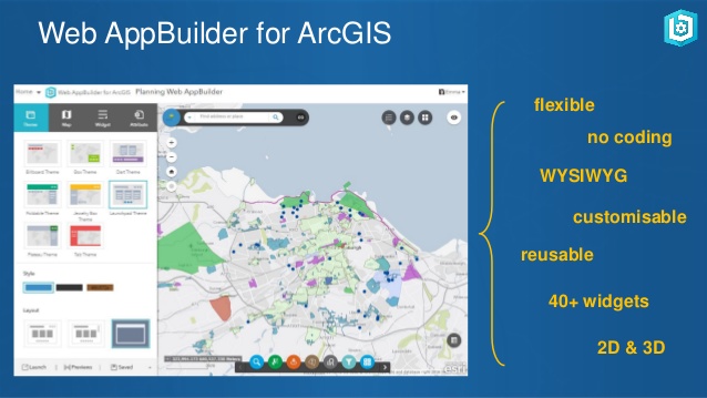
معرفی Web AppBuilder for ArcGIS

  • Web AppBuilder for ArcGIS includes built-in tools so you can create 2D and 3D web apps for your workflows and your brand. It's user-friendly, flexible, and full of GIS functionality.
  • Developers can build custom widgets and themes to extend Web AppBuilder for ArcGIS. Display and analyze your data on any device without writing code.

ساخت نقشه به صورت آنلاین (Online Map Developer)

با استفاده ازابزار  speciesMapper قابل دسترس درسایت speciesLink می توانید موقعیت نقاط  را به صورت لایه ای بر روی نقشه جهان مشاهده و چاپ نمائید.

البته در این سایت ابزارهای آنلاین مفید دیگری نیز قابل دسترس می باشند (infoXYconverter dataCleaning).


آدرس دسترسی:

http://splink.cria.org.br/mapper?&setlang=en


More:

speciesMapperPlot geo referenced points on a map.

speciesLink is a distributed information system that integrates primary data from biological collections. The development was funded by FAPESPGBIFJRS FoundationMCTICNPqFINEPRNP and CRIA.